


From celestial navigation to GPS technology, these sailing innovations have changed the way we take to the sea. And we couldn't do without them.
The first sailing boats:
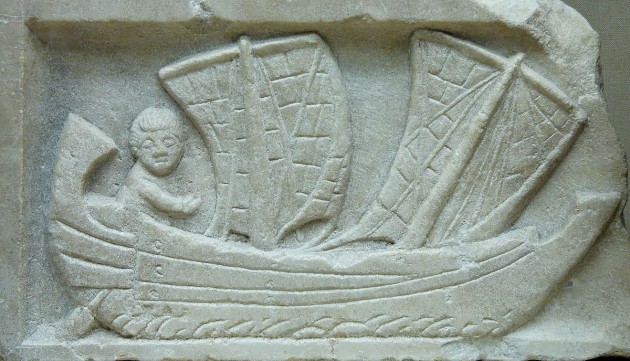
Visual depictions of sailing boats have been dated as far back as 5500 BCE, discovered on painted discs from ancient Mesopotamia found in modern day Kuwait. These sailing boats, used on the Nile River, were simple, square-rigged reed ships with a single square papyrus sail attached to a mast. Ancient civilisations including the Egyptians, Greeks and Romans all used sailing boats, and many cultures and practitioners have contributed to advancements in the science and practice of sailing over the millennia.
Polynesians sailed dugout outrigger canoes to colonise islands, using sticks to create navigational charts of wave patterns and currents that experienced pilots would commit to memory. Arab, Chinese and Indian cultures all had prehistoric sailing traditions. Although Norse Viking ships supplemented sail power with oars but managed to do that cross between the Atlantic’s northern islands, and as far as North America, mostly under sail. And European societies took up the mantle of innovating sailing technologies and techniques during the so-called Age of Discovery.
Steering oars and rudders:
As sailing and navigation increased in importance, ancient cultures began to innovate and improve sailing technology. One crucial technological advancement was the steering oar — an innovation that predated more modern stern-mounted rudders and allowed for the construction of larger boats.
A steering oar was a basic lever – typically an oversized oar or board – attached amidship on the starboard (an etymological derivation of the original ‘steerboard’) side of the vessel or at the stern. The innovation allowed a helmsman to pilot the craft more accurately.
Viking ships exclusively used steering oars. Smaller boats, for example punts on English waterways, still use a basic version of the steering oar.
The invention of the stern-mounted rudder is credited to the Chinese, who came up with the idea of affixing a manoeuvrable steering apparatus to the back of a ship’s hull during or before the first century AD during the Han Dynasty. It took Western civilisations another thousand years to affix a stern-mounted rudder to ships.

Celestial navigation by the stars:
The prospect of navigating through a featureless landscape – like the sea at night – is still a daunting one for the uninitiated, and the fact that ancient cultures were able to achieve it is a testament to human ingenuity.
Celestial navigation is the method by which ancient mariners piloted in darkness or when out of sight of land. The method requires angular measurements taken between heavenly bodies and the horizon as well as accurate time keeping to keep a ship on course.
Written records of the practice go back to the mythical text of Homer’s Odyssey written nearly 3,000 years ago. In the story, the nymph Calypso tells the hero Ulysses to keep the constellation of stars known as the Bear, Ursa Major and The Big Dipper, on his left hand side while observing the position of several other constellations to aid in his position.
The keel:
A structural beam that runs from a ship’s bow to its stern and sits lower than the rest of the hull, the keel was first invented by those intrepid Norse sailing men known as Vikings. Because their sailing ships were square-rigged, they were prone to making a lot of leeway when tacking close to the wind. The addition of a keel prevented this lateral movement, increased speed and made Viking ships more stable.
Initially, keels were small and didn’t increase boats’ draughts a great deal. Modern fixed keels can be quite deep and restrict yachts from sailing in shallow waters, but the innovation of fixed keels has also made designing for stability in modern boats much easier.
Many keels add ballast to boats and lower the centre of gravity, helping to keep them from capsizing. On racing yachts, for instance a canting keel provides righting momentum to keep the yachts upright.
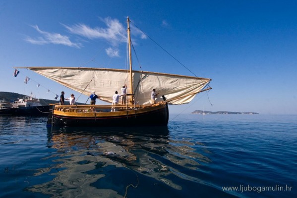
The lateen (triangular) sail:
One of the biggest jumps in the history of sailing technology was the invention of the lateen or latin-rig sail. The lateen is a triangular sail mounted at an angle and running in a fore-and-aft direction. With a manoeuvre called ‘tacking,’ the sail allows boats to make way to windward in a zig-zagging fashion.
Though its exact origin is unknown, the lateen sail is the earliest-known fore-and-aft rigged sail and was in use in Greece in the first century BC. It is believed to have been introduced to the Mediterranean region by Arabic or Persian sailors. Polynesians also invented a mastless lateen-rigged sail that is very different in construction from that used in the Mediterranean.
The lateen sail effectively allowed for the advent of the Age of Discovery.
The carrack and the first circumnavigation of the earth:
It was a carrack ship that completed the first full circumnavigation of the world. It took the Spanish expedition two captains and nearly four years to make the voyage. Portuguese captain Ferdinand Magellan, who initially led the expedition, set off from Spain in 1519 and died in the Philippines in 1521. Juan Sebastian Elcano brought the carrack ship Victoria – the only one of five ships that started the expedition to survive the trip – back to Spain in 1522.
Carracks were three- to four-masted sailing ships developed by Genoan sailors in the 15th century for use in commerce. Their spacious cargo holds made them good for long-distance exploration and they were important in advancing European colonial expansion leading up to the Age of Discovery. Ocean-going ships that were large enough to be stable in heavy seas, carracks were square-rigged on the fore and main masts and lateen-rigged on the mizzenmast.

Marine engines:
The carrack was by no means the final word in ship design, and faster ships – like the clippers – succeeded it and shortened the duration of trips to transport goods and people around the world. But the next major advancement in marine technology was the engine.
The first marine engines were steam powered and were adapted for ships nearly a century after Thomas Newcomen created the first commercially successful steam engine in 1712.
Scottish engineer William Symington built the world’s “first practical steamboat,” the Charlotte Dundas, in 1802. The first transatlantic trip by steamboat happened 17 years later in 1819 when another ship named Savannah sailed from Savannah, Georgia, in the US to Liverpool, England. Innovation of the technology continued throughout the 19th century and was eventually overtaken by diesel-powered engines. The obvious impact of the technology was to enable ships to sail at consistent speeds even when winds or sailing conditions were unfavourable.
EPIRBs :
The advent of Emergency Position-Indicating Radio Beacons (EPIRBs) has made sailing a much safer endeavour.
EIPRBs are tracking transmitters that communicate with the Cospas-Sarsat service, an international satellite system used for search and rescue (SAR) operations.
Although they can be manually activated, EPIRBs provide an additional measure of safety in catastrophic situations by the fact that they are automatically activated when, for example, a boat capsizes. The beacons send out a distress signal monitored by a worldwide system of satellites that aid rescue efforts to find survivors.
According to the Cospas-Sarsat service, since its beginnings in 1979, distress radio beacons have assisted in the rescue of tens of thousands of people in distress situations.

GPS navigation:
With the rather complex history of navigational techniques we’ve noted – from celestial to stick charts – a reliable way to find the position of your boat on the open ocean is of crucial importance.
The latest leap forward in navigation came when boats began to be equipped with GPS units. Operating in fundamentally the same way as the Sat Nav that guides you while you drive, Global Positioning System (GPS) receivers have made marine navigation less dependent on paper charts and more dependent on electronic ones.
GPS receivers are part of a space-based navigation system that provides location and time information in all weather conditions, anywhere on Earth where there is an unobstructed line of sight to four or more GPS satellites.
We’ve come a long way since the days of sailing by the stars. Now we’re sailing with the aid of heavenly bodies that are man made.
Internet on board:
Yes, believe it or not, it’s possible to logon and login while sitting on a boat in the middle of the ocean. But it’s not cheap.
The democratisation of information has hit the high seas with satellite internet options available far away from land and high-speed wi-fi from on-shore hotspots or personal hotspots transmitted via mobile phone.
The problem, however, is that the price is not very democratic. Depending on your desire for data, you can spend thousands on keeping connected.
According to service and hardware provider Global Marine Networks, the hardware setup for satellite internet can cost anywhere from $3,000 to over $15,000. And monthly tariffs run from $50 for email and weather data or into the thousands if you’re a heavy user.
Of course, costs will decrease as technology improves, and the fact that it’s even possible to stay connected to loved ones or even stream a movie while at sea is another sign that we’re living in a world only predicted by science fiction.
Related links:
Seasickness prevention and cure: the good, the bad and the dreadful
Quiz: can you identify these 14 “baby” sea creatures

13 Top female sailors
Here's our pick of some of the most inspiring yachtswomen. Who's your inspiration?

Delicious and easy to make cocktails for all occasions
From nautically themed drinks to winter warmers and summer coolers, these delicious cocktails are perfect for any occasion, whether you're…

A sailor walks into a bar…jokes to keep you laughing
Keep everyone entertained with our updated compilation of the best nautical jokes around..they're guaranteed side splitters!